Hello Reader,
Today I will be discussing my experience as a new user of
Web Soil Survey (WSS). It definitely seems like a useful tool for a variety of
projects, and provides a wide array of information about numerous different
aspects of a given area (big or small). Considering all its capabilities and
features, WSS was a little complicated for me to get the hang of initially, but
after playing around with it for a while and watching a tutorial, I was able to
navigate relatively easily.
The Area of Interest (AOI) I focused on was near the
Chattahoochee River National Recreation Area. I chose this location because it
allows me to focus on one section of the Chattahoochee River and the surrounding
area. I think it would have been difficult using this tool to outline the
entirety of the river, and even if I managed to do so using the drawing tool, the
amount of information (considering the length of the river) might have been overwhelming
since I have never used WSS before.
As I mentioned before, there are a lot of different things
that can be looked at using WSS, and so your map can look different and have a
different key based on what information you are trying to learn about your AOI.
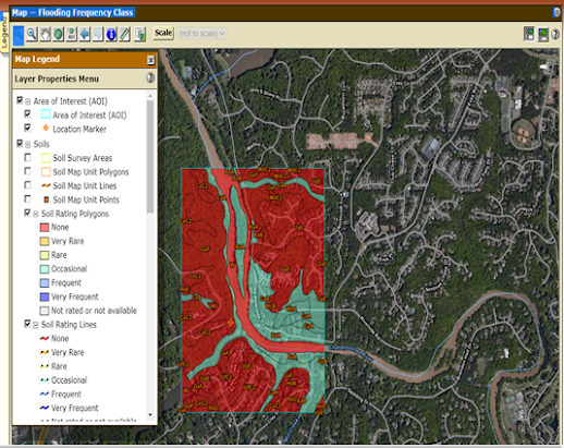
The image you see below shows my outlined AOI, the different soil types present
(represented by the orange letters), as well flooding frequency. According to
the map, flooding (at least in this particular area) of the Chattahoochee River
never occurs in certain areas, and only occasionally does in others). I was
surprised that there wasn’t any level of flooding in between occasional and
none, and perhaps this is something I can further explore. I am also curious
how the rest of the river compares in terms of flood frequency, so I’ll likely
be using this tool again to get information on that.
Overall, I think WSS is an awesome tool that can be utilized for a variety of purposes. I found it a bit confusing at first, but the more I use it the more I’ll understand it, I’m sure.
Thanks for reading,
Fran

No comments:
Post a Comment